What Is 3D Laser Scanning for Educational Institutions
3D laser scanning is reshaping how schools and universities manage their facilities and boost campus safety. Educational institutions now rely on LiDAR scanners to improve their operations. SWAT teams who studied interactive 3D maps for just one minute before entering a school building reduced their average response time to under 30 seconds.
This technology has revolutionized campus management and security planning. The widespread use of handheld scanners makes these skills vital for students to learn. Universities that use campus scanning technology have improved their safety protocols and shown their dedication to quality teaching and learning experiences. Complete mapping projects of public schools now merge with dispatch systems to substantially improve emergency preparedness. In this piece, we’ll explore how 3D laser scanning applies to campus mapping, as-built documentation of educational buildings, and the way BIM integration reshapes facility management in educational institutions.
Workflow for Campus Laser Scanning and Building Documentation
A small team of 2-3 specialized technicians starts the campus scanning process when they arrive with their portable equipment. The team first evaluates the scope and works closely with facility managers to avoid disrupting academic activities. Schools need to stay operational during these projects, so scanning work happens after hours or during holidays.
The specific campus needs to determine what equipment the team uses. Most teams use survey-grade laser scanners from Leica or FARO to document interiors, while drones capture complete exterior and roof information. SLAM (Simultaneous Localization and Mapping) technology helps teams document large academic spaces faster.
The team follows a clear workflow to process the captured data. Field crews upload scanner data to dedicated project folders where registration specialists combine multiple scans into one precise point cloud. These survey network adjustments achieve mean errors of less than 2mm. The team carefully removes unwanted “noise” while keeping the dimensions accurate.
The point clouds become useful deliverables that match client needs. These could be 2D CAD drawings, 3D BIM models, or virtual tours. The scan data also connects to State Plane or Site Grid coordinate systems. This helps institutions see how their campus buildings relate to each other in space.
Tools and Technologies for Educational Institutions
- Terrestrial Laser Scanners (TLS)
- Capture high-density point clouds of campus buildings and interiors.
- Typical capture rate: up to ~1M points/second.
- Mobile Mapping (SLAM Scanning)
- Rapid scanning for large indoor spaces.
- NavVis VLX used by Kansas State University.
- Typical deliverable accuracy: ~±5 mm depending on workflow.
- Aerial Capture (Drones + Photogrammetry)
- Used for roof conditions, façades, site context, and terrain modeling.
- Complements TLS for full campus coverage.
- Processing + Hosting
- Registration and alignment combine multiple scans into a unified point cloud.
- Datasets are typically hosted on cloud platforms for controlled access and collaboration.
- Education Licensing
- Artec Education Package 20 free software licenses
- Creaform ACADEMIA 50 complimentary software seats
- BIM + FM Integration
- Scan data integrates with:
- Revit BIM modeling
- Navisworks coordination/clash detection
- AutoCAD 2D drawings
- FM/CAFM/IWMS systems asset + space management
- Emerging Enhancements
- AI-based feature extraction for faster element identification and asset classification.
- AR/VR visualization for immersive planning, walkthroughs, and orientation.
Applications in Education Sector
Educational institutions now use 3D scanning technology in ways that go well beyond simple documentation. Schools and universities have found many creative applications in their academic settings.
Application Area | How 3D Scanning Is Used in Educational Institutions | Value / Outcome | Example / Notes |
Historic Preservation & Restoration | Scanning heritage buildings to capture accurate as-built geometry for conservation planning and restoration design. | Minimizes documentation errors, preserves architectural detail, supports restoration accuracy. | University of Toronto, Trinity College (1850s Gothic Revival buildings) scanned for restoration guidance. |
Campus Digital Twins | Creating digital replicas of campus buildings and infrastructure using point clouds + BIM integration. | Improves maintenance planning, space management, and lifecycle tracking of campus assets. | Kansas State University: improved collaboration across locations and access to reliable facility documentation. |
Hands-on STEM & Design Education | Using scanning + 3D printing to support project-based learning in engineering, architecture, health sciences, and product design. | Higher student engagement, improved collaboration, stronger understanding through tangible learning tools. | Research indicates students using scanning + printing score higher in satisfaction and learning experience compared to conventional methods. |
Virtual Learning & Immersive Experiences | Creating digitized environments and models to enable VR/AR learning, remote exploration, and interactive instruction. | Enhances learning accessibility and makes complex concepts easier to visualize. | Supports virtual trips, interactive exploration of structural systems, and spatial learning. |
Artifact & Object Digitization | Scanning artifacts and producing digital replicas for analysis, archiving, and 3D printing. | Enables preservation, replication, and controlled handling of sensitive objects. | Useful for museum collections, archeology departments, and research labs. |
Campus Safety & Emergency Response Planning | Using detailed 3D models to support emergency preparedness planning, evacuation route analysis, and responder orientation. | Faster incident response planning, improved situational awareness, safer evacuation workflows. | Police/first responders can review building layouts before emergencies. |
Advanced CAD / Engineering Workflow Support | Extracting geometry (planes, sections, profiles) from scan data for use in CAD/BIM workflows. | Accelerates modeling, improves accuracy for design documentation and renovation planning. | Students generate cross-sections and import geometry into CAD tools as reference data. |

Accuracy and Compliance in Public Buildings
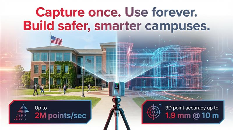
Accuracy and regulatory compliance are the life-blood of 3D laser scanning implementation in educational settings. The technology delivers remarkable accuracy within ±2 millimeters or better, based on equipment quality, methods, and scanning conditions. The Leica RTC360 scanner shows impressive 3D point accuracy of 1.9 mm at 10m, 2.9 mm at 20m, and 5.3 mm at 40m under optimal conditions.
- Schools must check scanning accuracy through regular walk-throughs of buildings and grounds.
- National school mapping standards don’t exist yet, but best practices help create datasets that first responders use via digital or paper maps. These materials need to be ready “at a moment’s notice” during emergencies.
- Local Education Agencies (LEAs) must keep data integrity and accuracy aligned with current site conditions. They should focus on capturing physical updates to floorplans after construction projects or changes to structures like relocatable classrooms.
- Government agencies now make use of information from advanced scanning to create detailed documentation. This supports everything from routine maintenance to large-scale renovations. Such an approach shows responsible management of public resources.
- 3D scans create permanent records of as-built conditions to ensure future work meets original standards and safety measures. These digital twins typically live on secure platforms like AWS and follow federal standards. The scans provide objective, verifiable data that proves regulation of compliance throughout projects, if disputes arise, whether contractual or legal.
Common Mistakes in Educational Scanning
- Poor scan planning: Wrong scan positions cause occlusions and missed areas.
- Uncontrolled site movement: Student foot traffic can disturb equipment and introduce noise/ghosting.
- Lighting variability: Direct sunlight and harsh shadows create artifacts, especially in colorized data.
- Calibration drift: Lack of calibration checks leads to measurement bias and inaccurate outputs.
- Insufficient scan overlap: Low overlap between scan stations causes registration errors and point cloud “holes.”
- Post-processing / registration errors: Weak control points and poor alignment can create drifts across large buildings or multi-floor scans.
Case Studies: Successful University Campus Scans
3D laser scanning and Scan-to-BIM adoption is accelerating across educational institutions because it solves a common challenge: campuses often operate with outdated drawings and limited visibility into existing conditions. The following case studies show how universities and schools are using reality capture to improve documentation accuracy, streamline renovations, and strengthen facility operations.
- Yale University: Campus Documentation
- Implemented campus scanning to replace unreliable legacy records with high-confidence existing-conditions datasets, improving long-term planning and facility decision-making.
- University of Chicago: Historic Main Quadrangle
- Used detailed 3D scanning to generate precise structural measurements and cross-sectional insights across historic buildings, enabling operations teams to visually validate building conditions and key elements digitally.
- Elementary School Renovation (Scan-to-BIM + MEP)
- Delivered an as-built model using 3D laser scanning and Scan-to-BIM, followed by clash-coordinated LOD 300 MEP BIM modeling, MEP shop drawings, and 5D BIM QTO/BOQ, supported by a structured BIM Execution Plan (BEP) demonstrating how scanning strengthens renovation coordination and reduces field conflicts.
- Kansas State University-Operational Efficiency with Campus Scanning
- Enabled improved cross-location collaboration and easier access to reliable “as-is” documentation, supporting engineering workflows and ongoing facility management.
These examples highlight a consistent pattern: when educational institutions invest in 3D laser scanning, they gain a repeatable source of truth for planning, renovation, and operational decision-making. From historic campuses to modern school renovations, reality capture reduces uncertainty, improves coordination across teams, and provides reliable digital documentation that can be reused across projects for years.
Conclusion
The growing adoption of 3D laser scanning across schools and universities signals a deeper shift in how educational infrastructure is being managed: campuses are moving from reactive maintenance and fragmented documentation toward data-driven facility intelligence. What once relied on outdated drawings, manual walkdowns, and institutional memory is increasingly being replaced by measurable, verifiable digital reality capture that can be reused across renovation cycles, safety planning, and long-term master planning.
In the coming years, the real value of laser scanning in education will likely extend beyond project execution. As institutions continue to invest in Scan-to-BIM and digital twin ecosystems, point clouds will become a long-term operational asset, supporting everything from capital planning to asset inventories, compliance audits, and emergency preparedness. The institutions that build this “source of truth” today won’t just modernize faster; they’ll reduce uncertainty across every future decision tied to their physical environment.
For education leaders navigating aging buildings, tight budgets, and higher expectations for safety and efficiency, the inference is clear: 3D laser scanning is no longer a specialized service, it’s becoming foundational infrastructure for smarter campus management.