Scan to BIM Services

Scan to BIM Services for Architectural, Structural & MEPF

Point Cloud Scan to BIM Services

Scan to BIM (Building Information Modeling) services is a process that involves creating a 3D BIM model of an existing building or infrastructure using 3D laser scanning technology. This process is used to capture accurate measurements of the existing structure and to create a digital model that can be used for various purposes, such as renovation, retrofitting, facility management, and asset management.

Point Cloud to BIM Modeling Services offer several benefits, including faster and more accurate data capture, improved visualization and analysis capabilities, and reduced costs and risks associated with physical site visits. They are commonly used in the construction and engineering industries, as well as in architecture, urban planning, and facility management. Our priority and commitment to deliver high quality project outcomes in quick turnaround time makes us one of the leading Scan to BIM Companies globally.

Our Point Cloud Scan to BIM Modeling Services Include

Laser Scan To BIM

We convert the precise laser scan point cloud data to information rich LOD 500 3D BIM model which can be used for professional design and maintenance of the building.

Scan To Revit MEP

We help in creating Mechanical, Electrical, and Plumbing models from point cloud data using Revit for refurbishments in commercial, and industrial buildings.

Point Cloud To CAD

We convert point cloud data into editable CAD drawings for residential, commercial, and industrial buildings for professional documentation and design process.

Scan to BIM for Heritage Building

We use innovative scan to BIM technology in the documentation and conservation of heritage buildings. Our experts visualize historical structures accurately and plan for future restoration works.

Scan to BIM Infrastructure Projects

We use laser scanning to capture precise measurements of physical structures or environments such as roads, bridges or railways. Our engineers ensure quality, minimizing risk throughout project life cycle.

Point Cloud to BIM Services for Commercial Projects

Through point cloud to bim conversion, we convert data into BIM Model for design analysis of residential & commercial projects. Point cloud to BIM modeling reduces time & costs of traditional survey.

Small building
Start utilizing laser scanning in your projects

For accurate and detailed measurement and building documentation 

Cost-Effective Benefits of Scan to BIM in Post Construction

For simple construction, remodeling, and refurbishment, point clouds used with BIM technologies provide exact and accurate models.

Scan to BIM Modeling Process

“Scan to BIM” refers to the process of taking a physical area and converting it into a digital model that may be used for project communication and information exchange with stakeholders as well as for planning, monitoring, or managing the built environment.

Reviewing input files

It is necessary to review the input files, which consist of scans and point cloud data.

Fixing orientation

To fix the orientation and new location of the point cloud, the coordinate equivalent of the scans are inserted. Work in the original coordinate system can be made easier by shifting base point.

Preparing logical coordinate system

A logical coordinate system helps our modeling team produce in Revit accurate point cloud displays and desirable graphical behaviors. To quickly visualize point clouds, we apply sophisticated techniques and tools.

Creating scan to BIM model

Our team used Revit to create Scan-to-BIM model at LOD 400 utilizing 3D survey measurements & photos. The deliverables improve insights for material estimation & renovation timeline.

Application of Scan to BIM Services

By creating a highly accurate 3D BIM model of an existing building or infrastructure, Scan to BIM services enable architects, engineers, contractors, and facility managers to better understand the physical space, identify potential issues, and make informed decisions. This can lead to improved project outcomes, reduced costs and risks, and enhanced sustainability and efficiency.

Why Choose TOPBIM Company

Scan Integration with Accurate Point Cloud

Better mapping and consistent point cloud transformation are aided by accurate point cloud alignment.

Correct point cloud alignment speeds up results by 15-20% at various stages, eliminating manual intervention.

Laser scanners produce 3D point clouds with extraneous object data, which we clean up before modeling.

Comparing scanned datasets with photographs & drawings, we enhance as-built consistency reducing RFIs.

Using precise positions from Google Maps and reorienting the building helps us solve orientation problems.

0 +
Completed BIM Projects
Scan to BIM Services

Our Projects

Speed Up Model Processing with Point Cloud Scan to BIM

Get a free quote for 3D BIM Laser Scanning for full density real-time modeling. Through visibility and graphical overrides, point cloud files in Revit improve real-time collaboration.

Please provide your contact information, and requirements for BIM 3D scanning or point cloud to Revit Model and we’ll respond right away.

Top BIM Company & Solutions

Frequently Asked Questions (FAQ)

Scan to BIM data makes it easier to create a precise Bill of Material, which reduces the likelihood of building budget overruns. In order to create an as-built model that is useful for facility management, maintenance, and operation operations, BIM models from laser scanned data are also used. 

A point cloud is a group of data points created in space by 3D scanners or Photogrammetry software. The laser scanner records an exact as-built of a structure or region, enabling the creation of a drawing of the existing building with its precise measurements and specifications.

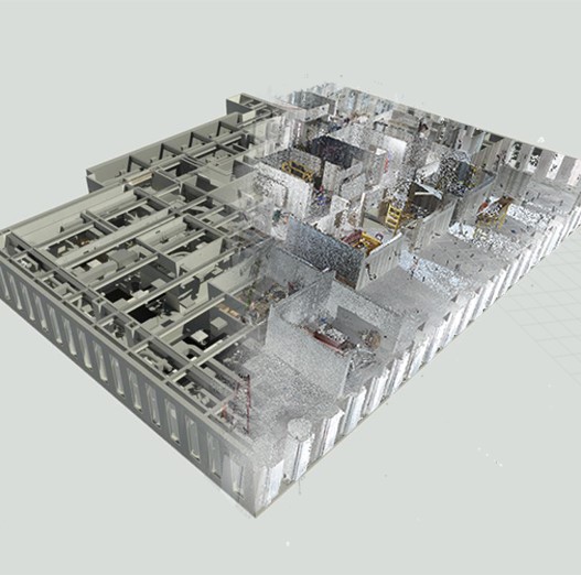
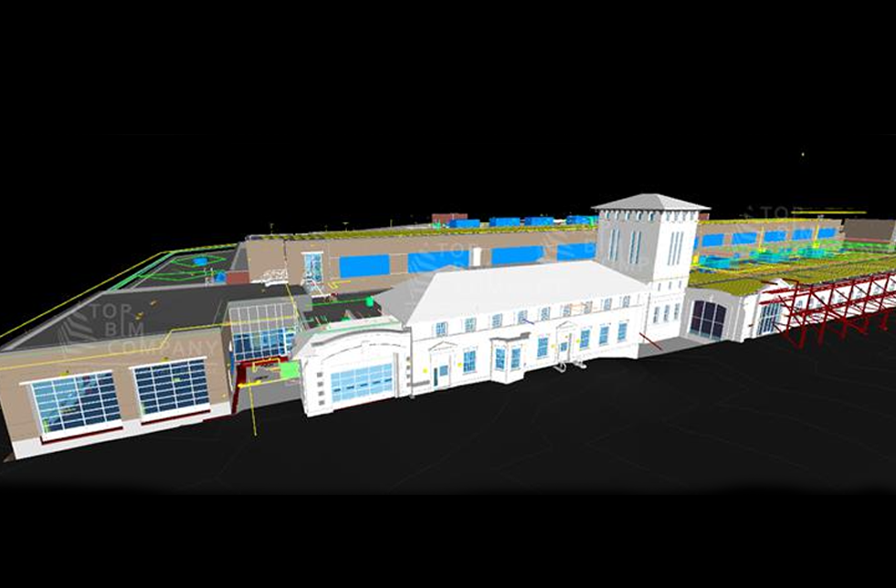
Point clouds are a byproduct of 3D scanning processes and are employed in a variety of ways, including the creation of 3D computer-aided design (CAD) models for manufactured parts, metrology and quality inspection, and a wide range of visualizing, animating, rendering, and mass customization applications. 

Using a 3D laser scanner to collect several points and measure an area is called point cloud scanning. With mobile mapping devices, you may easily create a point cloud to collect dimensions, size, and layout information.

Get a Free Quote

    Get a Free Estimation for your Project
    Please fill up the form to discuss your detailed project requirements and building design needs and we will get back to you soon.