Technology Type | Best Use Case | Accuracy Level |
Terrestrial Laser Scanners | Large-scale facilities, interiors | Sub-millimeter precision |
Mobile Scanning Systems | Linear infrastructure, fast capture | Moderate precision |
Drone LiDAR Systems | Site grading, topography, outdoors | Varies (depends on drone + sensor) |
Software Platforms:
- Registration & Cleanup: Leica Cyclone, FARO Scene, Trimble RealWorks
- Modeling: Autodesk Revit, Navisworks, Bentley
- Deliverables: Multiple file formats (RVT, DWG, IFC, etc.)
Aspect | Terrestrial Laser Scanning | Drone LiDAR |
Accuracy | Very high (sub-mm to few mm) | Moderate to high |
Best for | Interiors, MEP, detailed as-builts | Large outdoor sites, terrain |
Coverage | Limited per scan, requires multiple positions | Wide area coverage in less time |
Environment | Controlled, smaller zones | Rugged, open, long-range areas |
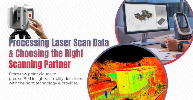
How to Decide the Right Solution or Provider for Your Project?
Red Flags to Avoid:
- Unrealistic accuracy claims.
- Promises of “fastest timelines” without methodology.
- Pricing that’s too good to be true.
- Limited portfolio or vague service descriptions.
- Outdated equipment and lack of certifications.
What to Look For in a Provider:
- Proven industry experience and relevant case studies.
- Updated scanning technology suited to your project.
- Rigorous QA/QC protocols.
- Deliverables in compatible file formats.
- Insurance and certifications for liability coverage.
- Clear communication and ongoing support.
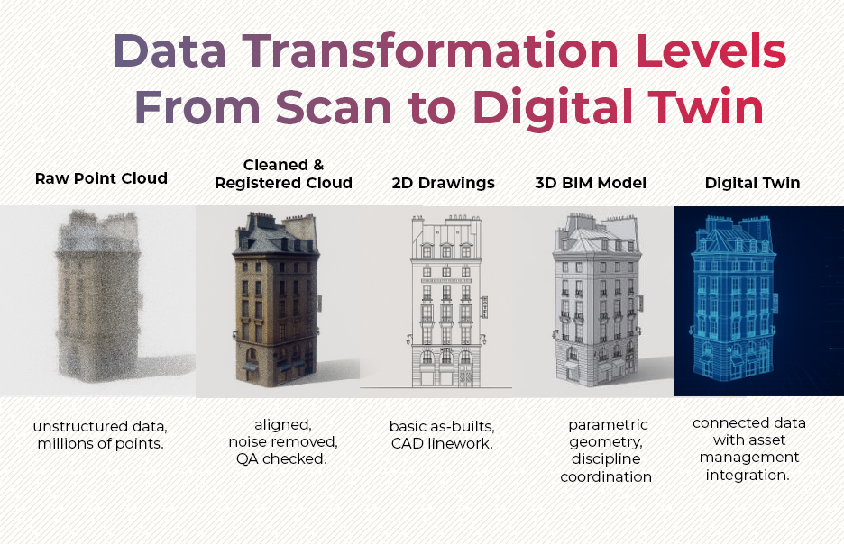
The success of a scanning project ultimately relies on a clear understanding of the entire data journey, from raw capture to final deliverables, combined with the selection of providers who bring proven expertise, rigorous quality assurance, and advanced technology investments to the table. Rather than focusing solely on cost, it’s essential to evaluate providers based on their technical quality, accuracy verification processes, and ability to deliver compatible outputs. By choosing the right partner, you ensure that raw point clouds are transformed into accurate CAD drawings, BIM models, or digital twins, keeping your projects precise, efficient, and on budget.
Frequently Asked Questions (FAQs):
Q1. What happens to the data after a laser scanning project is completed?
After scanning, the raw point cloud data goes through systematic organization, alignment, and quality verification. Technicians ensure precision by using reference targets, removing errors, and preparing the data for conversion into CAD drawings or BIM models.
Q2. How do professional providers ensure accuracy in laser scan data processing?
Providers follow strict QA/QC protocols, including cross-checking control points, validating dimensions against known references, and running Scan-to-CAD/BIM accuracy checks. This ensures the final deliverables are reliable and precise.
Q3. Which technologies are commonly used for laser scanning and data processing?
Experts use terrestrial laser scanners for interiors and detailed as-builts, mobile systems for fast linear infrastructure scanning, and drone LiDAR for large outdoor sites. Software like Leica Cyclone, FARO Scene, Trimble RealWorks, and Autodesk Revit are widely used for registration, modeling, and deliverables.
Q4. What is the difference between terrestrial laser scanning and drone LiDAR?
Terrestrial scanning provides very high accuracy (sub-millimeter to a few millimeters) and is best for interiors and MEP documentation, while drone LiDAR covers wide outdoor areas quickly with moderate-to-high accuracy, making it ideal for topography and site grading.
Q5. What factors drive the cost of a laser scanning project?
Costs depend on the type of equipment used (terrestrial, drone, or mobile), the scope and scale of the project, the required level of detail (LOD), and the deliverables (point cloud only vs. full Scan-to-BIM).
Q6. What should I look for when selecting a laser scanning provider?
Choose providers with proven experience, updated technology, strong quality control processes, compatible deliverables, proper certifications, and clear communication. Avoid providers with unrealistic promises, outdated equipment, or unclear portfolios.
Q7. Why is it important to focus on value and not just cost when selecting a scanning solution?
While cost is a factor, value comes from reduced rework, faster project approvals, safer operations, and long-term asset benefits like digital twins. A slightly higher investment in quality scanning can save significant time and costs later.
Further Reading:
What is Laser Scanning in Surveying and How Can These Solutions Benefit Your Business?
BIM for Sustainability and Energy Efficiency Modeling
Building Information Modeling for Infrastructure : Comprehensive Guide
Competitive Advantages Of BIM Automation In The AEC Industry
BIM for Heritage Preservation – Future of Protecting Our Past
Future-Proofing AEC Projects: The Role of BIM in Meeting Both ADA and OSHA Standards