Tools & Technologies for Oil & Gas Facilities
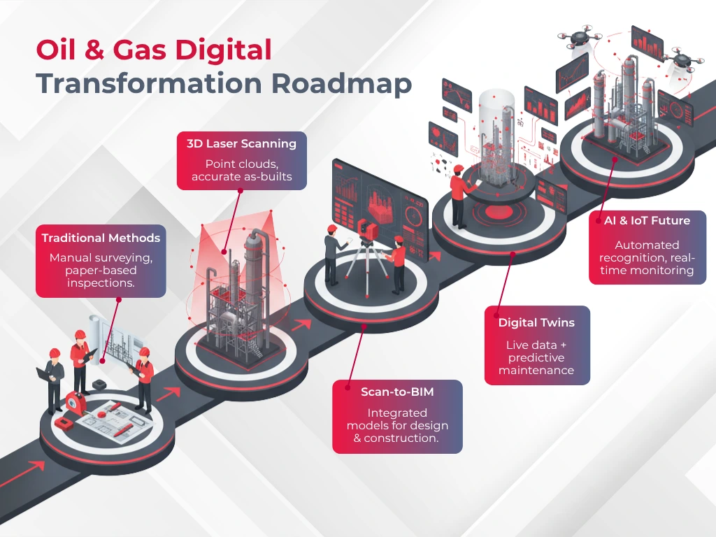
Scanning tools used in oil and gas projects have changed by a lot in the last decade. Modern scanners now capture more than 1 million measurement points every second. These scanners create digital replicas that mirror physical facilities with amazing accuracy.
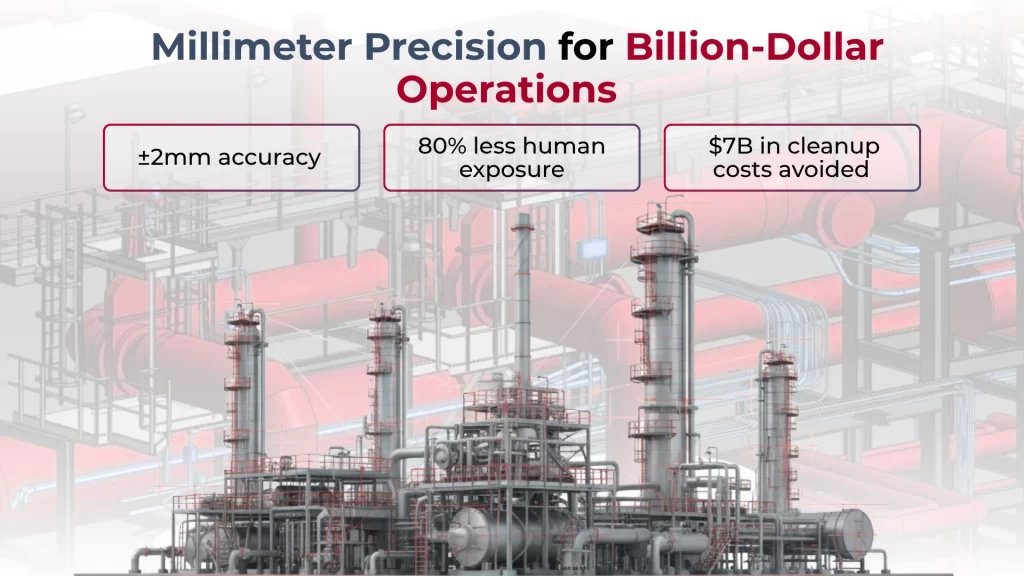
- Ground-based terrestrial laser scanners are still the go-to choice for most oil and gas work. These units are portable and deliver high-accuracy measurements (typically ±2mm at 10m range).
- Phase-based scanners work best in refineries and processing facilities because they balance speed and precision well. Time-of-flight systems are great for long-range work like pipeline corridors and large tank farms.
- Mobile scanning has become popular because it’s a quick way to document large facilities. These systems mount on vehicles or backpacks and combine LiDAR with inertial measurement units and GNSS technology.
- They create accurate point clouds while moving and cut field time by about 80% compared to static setups.
- Drone-mounted LiDAR is a great option for hard-to-reach areas or offshore platforms. These flying systems capture detailed data without needing framework or confined space entry. They can also use thermal and multispectral sensors to spot corrosion, leaks, and structural problems at the same time.
- Data processing has grown up too. Point cloud registration software handles billions of points quickly, and smart algorithms spot pipes, vessels, and structural elements automatically. This makes it easier to turn raw scans into smart 3D models.
- Reality capture software bridges field data and engineering applications. Engineers can spot clashes between existing conditions and planned changes, which stops costly field rework. They can see complex spatial relationships without entering dangerous areas.
- Digital twin platforms are the biggest breakthrough yet. These dynamic models mix 3D geometry with up-to-the-minute data analysis. They create living digital copies that track everything from pressure changes to equipment temperatures. This makes preventive maintenance work much better.
Applications in Oil & Gas Operations
3D laser scanning technology now plays a vital role at every stage of the oil and gas value chain and provides practical solutions to age-old industry challenges. The technology’s benefits go far beyond simple measurement, from the original site surveys to decommissioning processes.
- Scanning creates precise topographic models that help optimize well pad placement and access road construction during exploration and development. These models calculate cut-and-fill volumes for earthworks and identify environmental constraints before ground breaking begins.
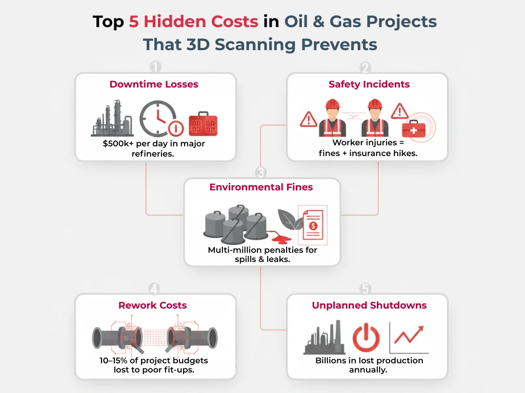
- Laser scanning has become an essential quality control tool in facility construction. Field teams exploit scan data to verify installation’s match with design specifications, which ended up preventing work that could get pricey. Engineers use as-built scans of existing facilities to design new components that fit perfectly on the first attempt.
- The technology’s role in asset integrity management proves crucial. Teams can measure deformation, corrosion, and settlement over time by scanning critical equipment regularly. This approach helps maintenance crews spot potential failures early instead of responding to emergencies.
- Pipeline operations see similar advantages from this technology. Right-of-way scans detect encroachments, geohazards, and unauthorized construction near pipelines. Specialized internal scanning tools document the pipe’s wall thickness variations and weld quality with millimeter precision.
- Scanning documents platform conditions on offshore facilities without sending personnel into hazardous areas. This reduces safety risks and operational downtime compared to traditional inspection methods.
The technology is a great way to get detailed records during decommissioning. These records support thorough planning for dismantling operations and environmental remediation efforts.
Accuracy, Compliance & Safety
Category | Key Points |
Accuracy | – ±2mm precision at 10–30m range |
Compliance | – Meets ASME B31.3 (process piping) |
Safety | – 80% less staff exposure to hazards |
Reliability | – Data validation with registration checks |
Foundation | – Supports compliance & safety protocols |
Common Mistakes in Oil & Gas 3D Scanning
The most important advances in 3D laser scanning technology haven’t prevented avoidable mistakes that still impact project success in oil and gas applications. Poor scan planning stands out as the main goal that derails projects.
- Teams often underestimate the coverage they need and leave data gaps that hurt the model’s integrity. The biggest problem comes from weak registration techniques.
- Point clouds don’t arrange correctly without enough overlap between scans – you need about 30-40%. This leads to measurement errors that spread through the whole model.
- Outdoor scanning faces tough challenges from nature. Data quality suffers from high temperatures, rain, and equipment vibrations nearby.
- Teams should schedule their scans during good weather and make sure their equipment stays stable, but many don’t take these steps.
- Resolution choices often go wrong because technicians use the same settings everywhere. Different facility areas need different detail levels – pipe racks need sharper scans than open spaces. Still, many teams stick to uniform settings throughout their projects.
- Messy data management creates problems later. Even perfectly captured scans become useless without proper file names and organization. This gets worse as projects grow bigger.
- Maybe even the most basic mistake is not having enough training. The fanciest scanning equipment won’t help if operators don’t understand its limits, best practices, and how to process the data properly.
Real Life Use Cases – Successful Oil & Gas Facility Scanning
Success stories from the ground show how valuable 3D laser scanning can be in oil and gas applications of all types.
- A prominent North American refinery discovered major differences between their documents and actual site conditions. Their engineers used over 500 million data points from 50 scan positions to spot spatial conflicts. This early detection helped them avoid work that would have gotten pricey during their planned expansion.
- The team at an offshore platform in the North Sea went through a full facility scan before upgrading their equipment. They completed the entire scan in just five days instead of the three weeks needed with old methods. This quick turnaround saved them about $175,000 in downtime costs.
- Pipeline operators have seen great results too. A scan of a 120-mile pipeline corridor revealed hidden encroachments and possible geohazards along the right-of-way. The team created a 3D model that helped operations staff plan maintenance based on actual risks rather than random inspection schedules.
These wins came from good execution and avoiding the mistakes we discussed earlier. The best projects share key features- solid planning, the right technology choices, good environmental conditions, and proper data checks.
These examples show the real benefits of well-implemented 3D scanning technology. Oil and gas facilities can now get accurate digital records to support safer operations, quicker modifications, and better regulatory compliance.
Conclusion:
The rise of 3D laser scanning signals a decisive shift in how oil and gas companies will operate in the future. Its precision and adaptability are not just incremental improvements over traditional methods, they redefine how safety, compliance, and efficiency are approached across the industry.
Firms that integrate scanning into their workflows will move beyond reactive maintenance and fragmented documentation toward predictive planning and fully digital asset management. As regulations tighten and risks grow more complex, reliance on accurate digital records will no longer be optional but expected.
The real advantage, however, lies in competitiveness. Organizations that embrace laser scanning today are not simply reducing hazards or cutting costs, they are positioning themselves as leaders in a safer, smarter, and more sustainable oil and gas sector.