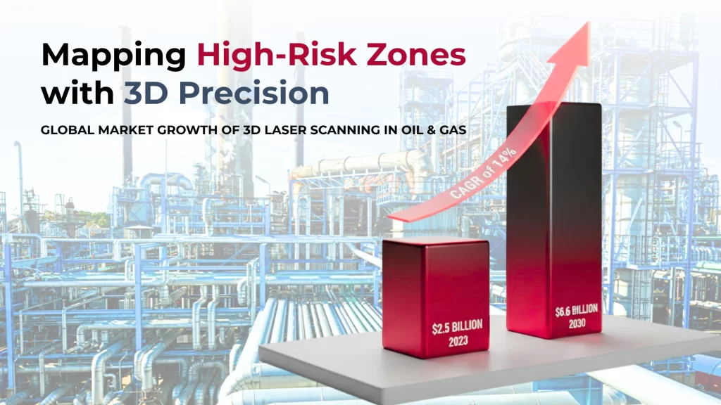
Comparing Workflows- Onshore vs. Offshore Operations
Laser scanning workflows are different between onshore and offshore oil and gas facilities. Each type comes with its own challenges and things that just need to be done. Onshore facilities give you a more controlled environment. Offshore platforms make things trickier because they’re remote and always changing.
- Onshore operations give scanner mobility a big advantage. Teams can move their equipment between locations in regular vehicles and finish multiple scans in one day. Safety zones are the main thing limiting access, not transportation issues.
- The stable ground also gives teams a reliable platform to work from, so they don’t need special equipment to deal with movement.
Offshore scanning takes much more planning. Teams must move their equipment by helicopter or boat, and everything needs special packaging to handle the marine environment.
- The weight and size of scanners really matter because moving anything offshore can get pricey. Floating platforms never stop moving, so teams need advanced stabilization tech to keep their scans accurate.
- Weather barely affects onshore scanning but can stop offshore work completely. Strong winds, rain, or extreme temperatures often cause delays. Teams need flexible schedules and backup plans. These delays usually make projects take 20-30% longer than similar work onshore.
Here’s how the core operations match up:
Factor | Onshore Operations | Offshore Operations |
Equipment Transport | Standard vehicles | Helicopters/vessels |
Scan Time | Typically 1-2 days | Often 3-5 days for similar scope |
Environmental Challenges | Limited | Significant (weather, motion) |
Data Transfer | High-speed connections | Limited bandwidth satellite |
Personnel Requirements | Smaller teams | Larger teams with marine certifications |
Data handling shows another big difference. Onshore teams usually have fast networks to transfer data right away. Offshore teams deal with slow connections, so they must process data on board or physically transport it. Teams must check data quality before leaving to avoid expensive return trips.
Both environments benefit from new portable, tough 3D laser scanning systems. These systems handle rough conditions while staying accurate down to the millimeter.
Advanced Tools & Technologies in Oil & Gas 3D Scanning
Tool / Technology | Primary Use | Key Features | Oil & Gas Value |
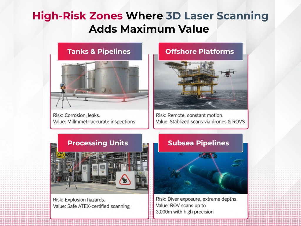
ATEX-Certified Scanners (e.g., Imager 5006EX) | Explosion-risk areas in processing units, pits, tanks, pipelines | – Explosion-proof (Group I & II certified) | Safe scanning in hazardous zones without worker exposure |
Fixed-Wing VTOL Drones with LiDAR | Surface surveys & pipeline corridors | – Cuts through vegetation | Boosted uptime in maintenance (e.g., vapor recovery unit uptime from 60% → 99%) and $500K+ annual savings |
ROVs (Remotely Operated Vehicles) with Laser Scanners | Subsea pipelines & underwater infrastructure | – Resolution 100x higher than acoustic methods | Eliminates diver risk, captures accurate data without stopping operations |
Deliverables & Value for Engineers, Contractors, and Asset Owners
3D laser scanning produces valuable outputs that benefit the oil and gas value chain. The key outputs from these systems include precise point cloud data, detailed 2D CAD drawings, detailed 3D BIM models, and interactive viewers like TruView. Users can access these outputs in various formats (.e57, .rcs, .dwg, .rvt) that work seamlessly with industry-standard software such as AutoCAD, Revit, and SolidWorks.
Engineers benefit from unprecedented accuracy—within millimeters. This eliminates guesswork and creates reliable digital twins that reflect real-life conditions instead of theoretical ideals. The system’s precision allows 100% pre-fabrication before project implementation and eliminates expensive rework.
Many producers now require laser scanning for bid eligibility, giving contractors a competitive edge. The technology cuts down field verification time by capturing detailed data in one visit and minimizes costly return trips.
Asset owners see the most significant benefits through better asset documentation, condition monitoring, and maintenance support. The system can scan stockpiles to estimate quantities accurately and make tank calibration more precise. Most projects recover their investment within 9 months and see 40-50% faster time-to-market.
The financial benefits go beyond direct savings. Reduced downtime, better safety measures, and longer asset lifecycles work together to maximize return on investment.
Integration with Digital Twins & Asset Management System
3D laser scanning systems paired with digital twin technology mark a breakthrough in the oil and gas sector. Digital twins create virtual copies of physical assets that monitor and simulate different scenarios. These digital versions work as accessible spatial indexes to find vital asset data.
Quick 3D scanning methods feed these twins with exact point cloud data. The result? Precise virtual models that match ground conditions. These scans prove more reliable than older BIM or CAD models.
The models’ merger with enterprise asset management (EAM) systems improves operations significantly. This process needs three vital types of data:
- A 3D point cloud
- Images of the area
- GeoTags connecting physical assets to digital versions
Companies that add live sensor data to these models see remarkable results.
Case studies show a 90% drop in data processing time and 25% better field operations. Asset owners can see vital measurements like temperature or valve conditions right on their digital twin.
This technology does more than just show data. It spots problems before they get pricey and helps predict maintenance needs. Smart maintenance scheduling cuts downtime and extends equipment life. This shows how technology creates excellence even in tough environments.
Conclusion
On refinery floors and offshore rigs, where workers once balanced on scaffolding with clipboards and tape measures, scanners now hum quietly, capturing millions of data points in seconds. The change is not just technological; it’s cultural. Engineers no longer argue over measurements but over models, contractors share data in real time, and maintenance teams plan around digital replicas instead of paper drawings that may or may not be accurate.
The technology’s appeal is also pragmatic. As one project manager in the Permian Basin noted, “It saves money, but more importantly, it saves hours in places we’d rather not send people.” That sentiment resonates in an industry where safety is as valuable as speed, and where reputational risk from accidents can be as costly as operational downtime.
Yet the shift is not without challenges. Scanners must still contend with hostile marine environments, bandwidth bottlenecks offshore, and the steep learning curve of data-heavy workflows. Smaller operators worry about costs, even as early adopters argue the investment pays back within a year. But the momentum is unmistakable. Analysts see 3D scanning as a foundational layer for digital twins, predictive maintenance, and even future AI-driven plant operations.
What emerges is a picture of an industry in transition: not abandoning the old, but overlaying it with new precision. As regulations tighten and margins narrow, oil and gas companies are embracing tools that allow them to see more, risk less, and act faster. If the last century of energy infrastructure was built on steel and labor, the next may well be built on point clouds and pixels, an invisible architecture shaping the physical world, one millimeter at a time.