Geographic Information Systems are systems that process including, store, manipulate, analyze, integrate, and display data. GIS (Geographical Information System) is useful for transportation planning, urban planning, and disaster management.
Disaster prediction can be made using a lot of data, which is available in hundreds of thousands of information such as population and age, gender details, utility service information, land details of the whole state, and so on.
GIS (Geographical Information System) could be deployed in the counter plan against varied disaster management needs. Before jumping onto how GIS aids in specific disaster needs, let us understand the term “disaster” itself.
Disasters
Natural disasters are dangerous events caused by natural processes on earth. An example of a natural disaster is a flood, earthquake, hurricane/cyclone, volcanic eruption, tsunami, and other geological processes. Man-made or anthropogenic disasters are caused by human activities.
Anthropogenic disasters adversely affect humans, other organisms, and finally the ecosystems. Examples of man-made disasters include all types of pollution, nuclear disasters, chemical disasters, biological disasters, terrorism attacks, and other accidental disasters. Now let us get on the usage of GIS in each of the specific disaster and their occurrences –
Floods
Effective and cost-effective flood prediction has been achieved by the National Disaster Management Authority and State Disaster Management Authority through the use of remote sensing and GIS technology. With the use of GIS technology, flood-prone areas may be located, shelter can be provided, and appropriate retaining wall and stormwater drainage systems can be designed.

Rescue teams can also use these maps to generate base maps and vulnerability areas. More details on the effects of disasters are provided by the 3-Dimensional flood simulation findings. We also investigate flash floods, which are brought on by a lot of rain and melting snow.
- Identification of critical areas
- Planning important flood resistance infrastructure
- Optimized rehabilitation efforts post-occurrence
Earthquake
The planning and analysis of earthquakes has been transformed by GIS technology, which also helps emergency groups manage and organize their operations. Urban information systems are used to assess infrastructure locations and demographic data, while remote sensing and GIS technologies are used to offer accurate spatial data for historical sites.
While network analysis aids in the identification of emergency routes, buffer analysis aids in the prediction of damage from fires and tsunamis. Users may engage with maps, determine the position of earthquakes, and send information to relief teams using real-time location tracking systems and applications.
- Well thought land regulation as per earthquake norms
- Data-driven rescue operations post-event occurrence
- Urban development effort could be translated well into a single building effort
Cyclone
Global topographical and meteorological data are gathered by remote sensing technologies in order to track and anticipate natural disasters such as heat waves, droughts, and climate change. GIS technology supports strategic decision-making, disaster planning, and impact monitoring of climate change.
It supports government and non-governmental organizations in disaster management by assisting in the discovery of patterns and relationships in geospatial data. Additionally, GIS technology helps identify places most impacted by climate change and anticipate future dangers.

Image Source: sciencedirect
- Aid in planning infrastructural assets mitigating cyclone and its effects
- Swifter response with thorough digital data-driven mapping
- Detailed documentation of the event for a rebuild for next occurrence
Landslides & Avalanches

Image Source:researchgate
By providing access to historical data, GIS technology raises public awareness through the use of vulnerability maps and climate risk time notifications.
Along with integrating quantitative and qualitative data, it offers user interfaces for several theme layers, overlay analysis, raster and vector analysis, and query building. Reducing the need for databases, GIS helps forecast avalanche and landslide disasters.
Biological disasters
When it comes to handling biological catastrophes such as COVID-19 and locating hotspots, GIS technology plays a critical role in healthcare. It helps locate medical facilities, quarantine centers, and COVID-19 positive patients. It also facilitates the effective administration of vaccines.
Additionally, to detect unintentional hazard hotspots and provide society cost-effective and efficient safety, GIS, GPS, and communications technologies are employed.
- Population data in combination with GIS is optimal for next pandemic
- Masses data which the healthcare industry lacks for healthcare AEC development
- An intelligent medical infrastructure projection backed by data

Disaster management has two parts which are Pre-Disaster and Post-Disaster events. If GIS is part of the whole management process throughout, it could be beneficial at every point of the execution –
Pre-Disaster Stage
Mitigation and Preparation process activities need to be planned to reduce the impact of the disaster.
Mitigation: Minimize the effects of the Disasters before their occurrence.
GIS technology is used by governments and rescue organizations to apply construction rules, land use and zoning regulations, elevating dwellings in flood-prone locations, and awareness campaigns in order to lessen the impact of catastrophes. With interactive visualization, GIS-based projected disaster maps assist in creating mitigation strategies, both short- and long-term, by pinpointing important locations.
Preparedness: Involves the development of an emergency operations plan.
Rescue teams from the federal, provincial, or municipal levels are prepared to put together an emergency operation plan that includes a disaster response checklist for communities and data sharing between federal and non-federal organizations. the creation of a geographic database that lists the locations of infrastructure assets, including generators, construction equipment, shelters, and medical supplies.
Post-Disaster Stage
Response and recovery measures are being taken to return to normal life.
Response: Emergency helps the people
When a crisis strikes and people want emergency help, geospatial data may be utilized to find the answers to user inquiries about things like health facility operations, possible temporary shelter places, and more. During the time of fighting against a disaster, the federal, state, or relief team addresses and responds to everyone in need with the use of GIS technology.
Back to Normal Life after the occurrence of the Disaster Event
Because it can detect and solve potential disasters before they happen, GIS technology is essential to disaster management. It offers immediate objectives including rehabilitation tracking, environmental monitoring, and financial assistance for quick healing.
Better recovery and rebuilding efforts, as well as mitigation strategies, are part of long-term aspirations. In order to help rescue crews and anticipate weather, GIS technology is integrated with GPS. It also establishes an emergency database for those in need of help, including shelters and hospitals in the area.
Vulnerability is decreased using GIS maps, which show historical and past catastrophic events. Natural catastrophes can still occur, but their effects and destruction can be reduced by technology.

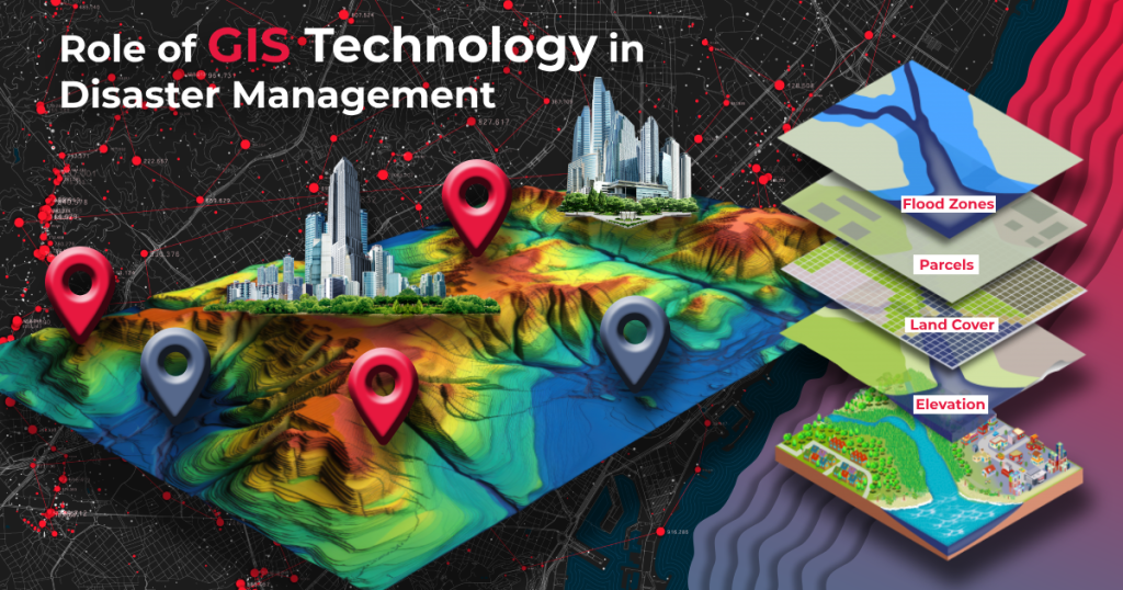
Geographic Information Systems (GIS) provide tools and methodologies to collect, analyze, display, and distribute spatial data linked to natural hazards, which is important for hazard mapping and natural disaster management. This is how GIS is useful in this field:
Integration of Data
Integration of many geographical data types, including topographic maps, geological data, climatic data, satellite images, and more, is made possible by GIS. Understanding the geographical linkages between the many components that contribute to natural disasters is made easier by this thorough data integration.
Identification and Evaluation of Hazards
Numerous hazards, including hurricanes, landslides, wildfires, floods, and earthquakes, may be recognized and evaluated using GIS. With the use of GIS, specialists may evaluate the possible danger and consequences of these risks in particular locations by examining past data, topographical features, and environmental variables.
An analysis of vulnerabilities
Within regions that are prone to hazards, GIS makes it possible to identify populations that are at risk as well as infrastructure, including roads, buildings, and other facilities. Planning escape routes, creating robust infrastructure, and assigning funds for disaster response all depend on this knowledge.
Zoning and Mapping for Risk
With the use of GIS, risk maps specific to hazards may be made, identifying locations with different degrees of danger. Decision-makers can use these maps to prioritize locations for land-use rules, emergency response plans, and mitigation measures.
Simulating and Modeling
Using GIS techniques, models and simulations may be made to forecast the possible effects of natural disasters. Flood inundation modeling, for instance, can assist authorities prepare for evacuation and resource allocation by illustrating how water might spread during a flood event.
Planning for Emergency Reaction and Evacuation
During a disaster, GIS helps emergency responders by providing real-time data on the location of affected areas, available resources, and evacuation routes. This information improves decision-making and coordination among response teams.
Resource Allocation
Based on the population density and spatial distribution of the impacted regions, GIS helps to optimize the distribution of resources, including manpower, emergency supplies, and medical services.
Education and Public Awareness
Maps and visualizations created using geographic information systems (GIS) are useful resources for informing the public about possible dangers, safe areas, and evacuation routes. This promotes awareness and motivates people to act appropriately in emergency situations.
After-Disaster Damage Evaluation
When a disaster strikes, GIS helps expedite the damage assessment process by superimposing pre- and post-disaster imagery to detect alterations in the terrain and infrastructure. Efficient allocation of recovery resources requires this knowledge.
Long-Term Planning and Mitigation
GIS is all about long-term disaster risk reduction and mitigation strategies by singling out areas prone to greater threats. This could further optimize the land-use planning, structural improvements, and ecosystem-based approaches on that particular area.