GIS for Urban Planning | Application, Tools & Benefits

GIS for Urban Planning | Benefits, Applications, & Tools

What is Urban Planning? 

Urban planners design cities for future improvements and growth, including streets, parks, and public spaces. Originating in the 19th century, they believed that separating urban areas into residential, business, and industrial districts would improve public health. Modern planning now considers factors like bike lanes, walkability, and traffic flow.

However, many cities are facing population loss, necessitating planning for vacant land. Geographic information systems (GIS) have become an essential tool for urban planners, enabling database creation, spatial analysis, modeling, and visualization.

Unlock the Power of Geospatial Intelligence with Our Cutting-edge GIS Services

Benefits of GIS in Urban Planning

Benefits of GIS in Urban planning

With time, GIS in urban planning will become more and more beneficial. 

The early use of GIS in urban planning was hampered by the high expenses associated with setup and maintenance. Nonetheless, use has risen as GIS software has been more approachable and hardware has become more affordable. 

There are numerous benefits of using GIS in urban planning, but here are the top five. 

Better mapping

GIS can boost the effectiveness of thematic mapping, reduce data storage costs, and enhance map currency (whether or not a map is current) with a single source for both historical and current data and maps. 

Easy access to important data

Data from many sources may be more easily stored, managed, and accessed with the use of desktop GIS. The same advantage is provided by cloud GIS, which also permits access from any device. 

Enhanced Interaction

Instead of searching through files, hard drives, or several departments for information, internal parties may obtain the information they want instantly using a single system for data management and storage. 

Better efficiency and quality in public services

A public-facing portal, such as this one, may be made with GIS, facilitating information sharing between public and government entities. While the public has self-serve access to the information they require, government personnel are able to communicate information rapidly. 

A stronger endorsement of strategic decision-making

Quicker access to a greater variety of crucial geographic data allows planners to develop well-informed strategies more successfully. Furthermore, they may investigate a greater variety of “what-if” situations, which should ultimately result in more robust and successful long-term plans. 

How does GIS achieve these benefits? Let’s take a look. 

GIS Tools for Urban Planning

GIS tools for urban planning

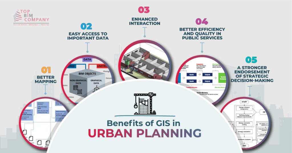
Urban planning may make use of the many features that GIS systems offer. Among the most often used are database administration, visualization, geographic modeling, and spatial analysis. Let’s examine each in brief. 

Database management 

The process of creating, importing, maintaining, and using all data that enters and exits a GIS platform is known as database management. 

This includes land use maps and plans, planning applications, socioeconomic data, and environmental data storage for urban planning. 

Cities, as you may imagine, generate enormous amounts of data in a variety of formats. GIS offers a single database where all of that information may be kept and arranged conveniently. Urban planners may easily access data by using spatial searches after it has been uploaded to the database. 

Visualization 

Maps are frequently referred to as visualization in the context of urban planning. 

Planners may build maps (often even in 3D) with the use of desktop GIS’s robust mapping visualization capabilities. These maps may be made with the assistance of environmental and socioeconomic data, which can also be added later as a supplementary data source. 

Urban planners find it simpler to investigate options and make judgments when using digital maps. Choosing the best site for a new park or public area, as an example. 

Spatial analysis & modeling 

Spatial analysis and modeling are made possible by GIS in urban planning and can help with a number of crucial activities related to urban planning. 

The aforementioned duties encompass site selection, impact evaluations, land suitability studies, land use and transport modeling, and the identification of planning action areas. 

Urban planners may accomplish these goals with the use of GIS features including interpolation, buffering, map overlay, and connection assessment. 

Field data collection 

People’s perception of GIS was based on large, locally installed software for many years, on desktop or laptop computers in the back office. It is evolving. 

Urban planners may now perform field research, examine dynamic maps on their phones, gather important data, and input field data back into a desktop GIS thanks to the development of mobile GIS. 

Automate your GIS data management and streamline construction workflows with TopBIM's GIS services.

Practical Applications of GIS in Urban Planning

Let’s breakdown the various practical applications of GIS in urban planning. 

Resource inventory 

GIS systems reduce the amount of time needed to gather data on land use and the environment, particularly when combined with remote sensors. Urban planners can employ distant photos to identify changes in the land use of an entire urban region as well as existing land usage. With 3D CAD models, these pictures may also be utilized to produce eye-catching visualizations. 

Creating land-use maps & plans 

Future land-use maps serve as a community’s roadmap for planned developments, public areas, and infrastructure. By using these maps, a city may make sure that its urban design takes pollution control, pollution prevention, transportation issue mitigation, and urban sprawl limitation into consideration. 

Urban planners may easily construct maps of the current city using GIS, and they can then examine future possibilities using different modeling and predictive data tools. Ideally, this process will result in the creation of a sensible, sustainable, and accurate future land-use map. 

Planning applications 

Businesses and the government may both process and arrange planning applications with the use of GIS. 

It is possible to make many GIS portals public facing, allowing users to view information on county and district boundaries, area zoning, and parcel outlines and details. When everyone has greater access to essential information, government resources that may have been used to locate the data and respond to these requests can be used elsewhere. 

Moreover, organizing, processing, and status monitoring become considerably easier when all the apps are housed in a single database. 

Analyzing socioeconomic & environmental data 

Future land-use maps need to estimate future land resource demand while accounting for many environmental conditions. Spatial distribution, economic activity, and demographic statistics are all necessary components of modeling. 

GIS’s visual component facilitates the easier and more efficient analysis of location-based data, such as environmental and socioeconomic trends. Thematic maps, or maps that blend location and data to examine relationships and illustrate patterns, are made possible by GIS. 

Users may readily discover ideal places and possible conflict areas by creating layered pictures that incorporate topography, street maps, thematic maps, and other data sets recorded in the GIS database. 

Land suitability analysis/site selection 

Urban planners may do land suitability study, a crucial stage in site selection, with the use of GIS technologies like map overlay. 

Urban planners may identify environmentally sensitive locations with the aid of remote sensing, spatial searches, and environmental data analysis. They can locate any regions where possible development and the environment clash by superimposing maps of land suitability over actual land development. 

Measuring connectivity 

The spatial analysis, buffering, and map overlay geoprocessing features of GIS aid in the evaluation of connection for urban planners. 

The term “connectivity” describes a city’s walkability or bikeability. People living in a well-connected location will have several alternatives for getting from point A to point B in a hurry. 

Impact evaluations 

Urban development’s possible impacts on the environment may be assessed through an environmental impact assessment. If problems are discovered, the urban planner can then suggest solutions to lessen or prevent undesirable effects. 

Monitoring, assessment, and feedback 

GIS technologies may be used to assess a building plan, track the project once it is finished, and even get input for future changes. 

GIS can assist planners in monitoring whether development is according to the area’s land use plan in conjunction with remote sensing. They can assess the effect and make any modifications with its assistance. 

Empower your urban planning decisions with GIS.

GIS is revolutionizing the way cities are planned and managed. With GIS, planners can

Case Study: Utilizing GIS for Urban Planning in Kigali, Rwanda

GIS technologies were employed by Rwanda’s Kigali Urban Planning and Management Capacity Building (KUPMCB) to stabilize urban planning in the city. Along with producing a digital basemap and an inventory of existing maps and plans, the KUPMCB also carried out fieldwork and research to collect more data 

In addition, they produced a suitability map, thematic maps, and aerial surveys to update the basemap. Urban planners may build towns and cities with the use of GIS, be ready for new construction, and make modifications when the population shifts.  

Unearth’s Mobile GIS enables consumers to discover the potential of GIS on any device, without the need for technical expertise or a degree. Urban planners may swiftly produce maps of the city as it is today and utilize modeling and predictive data approaches to investigate future possibilities by processing geospatial data from satellite imagery, aerial photography, and remote sensors. 

The future of development would be data-driven and GIS would ensure it

Development not in a planned manner is not development and that too in the 21st century. The urban problems are more complex than ever before. Growing population, the economy in turbulence, and clouds of the next big pandemic already being here.

You definitely need a data-driven urban planning and development approach. Something is based on predictive maintenance rather than reactive. Waiting for something to happen and then reacting would cost us billions of dollars.

This is exactly the principle of coupling GIS with urban development benefits. GIS would let us visualize the data and then plan our urban progression accordingly. With AI also coming in critical parameters could easily be automated in the urban development workflow. Remember, the future is data interoperability and lots of that data is goanna come from GIS!  

Our Services
Latest Post
Get A Free Quote

    BIM Construction is the Future

    Building information modeling (BIM) is the future of building design and construction. Get in touch with our BIM Experts.

      Join our Newsletter

      Subscribe to our newsletter to get latest updates